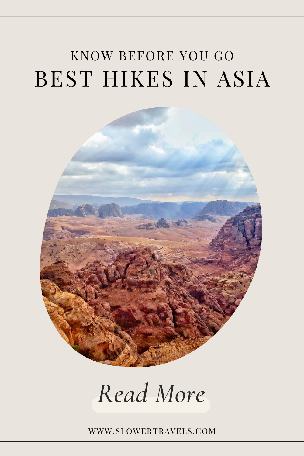
11 Best Hikes in Asia
This post may contain affiliate links, meaning we get a commission if you decide to purchase through our links at no cost to you. This helps fund Slower Travels without costing you a cent!
Some people like to lie by the pool on their holidays. Others like to visit ancient temples. But one of the best things you can do on a holiday is get outside into the great outdoors.
Asia is a diverse continent stretching from the edge of Europe in the West through to the many islands of Indonesia in the East. Choosing a hike in such a vast area can be challenging.
We’ve gathered advice from real people who have been out there walking these trails to tell you the best places to hike, from Tajikistan to Sri Lanka, Thailand to China. Whether you’re looking for mountain tops or deserts, solo missions or small group options, multi-day or day hikes, there is a hike in Asia that is perfect for you.
-
China: Plank Walk at Mount Huashan
India: Dzukou Valley in Nagaland
India: Kashmir Great Lakes
Indonesia: Mount Batur Sunrise Trek in Bali
Indonesia: Mount Bromo in Java
Jordan: Umm Al-Biyara at Petra
Jordan: Wadi Mujib Canyon
Nepal: Everest Base Camp
Sri Lanka: Ella Rock
Tajikistan: Engel’s Peak Meadows
Thailand: Emerald Lagoon
Kashmir Great Lakes in India
One of the most spectacular treks in India is the Kashmir Great Lakes Trek. Located in the Kashmir Valley, Indian Himalayas, this hike takes you through the lush green meadows, dense forests and rugged terrains. This trail has a series of alpine lakes, each more mesmerizing than the last. From turquoise lakes such as Vishnusar and Krishansar lakes to the clear waters of Gadsar, Satsar, and Gangbal lakes, this trek feels like scenes from a fairy tale.
The trek is a challenging trek spanning six to seven days, taking the trekkers to an altitude of 4,191 metres (13,750 feet). Proper acclimatization, fitness, and a good guide are essential, as the trek involves high altitudes and remote stretches. Prior permission from the Indian army needs to be obtained to do the trek.
The best time to undertake this trek is from July to September, the summer season, when the weather is pleasant and sunny. What makes this trek truly special is the varied landscapes it offers. You start the trek by traversing through the meadows and streams and climbing to ascend the steep ridges. Along the way, you meet the locals and the shepherds grazing their cattle and sheep.
Shared by Raksha Nagaraj from SOLOPASSPORT

Image provided by SOLOPASSPORT
Mount Batur Sunrise Trek in Bali, Indonesia
The Mount Batur sunrise trek is, without a doubt, one of the most fabulous hikes one can do in Southeast Asia. Mount Batur is an active volcano located in the north east of the island of Bali.
It is a one-hour drive from Ubud or a little less than 2 hours from the Seminyak and Canggu area. The journey through the island is worth it: you’ll drive past some of the best Bali waterfalls and landscapes.
The Mount Batur hike starts in the early hours of the morning, typically around 2:00 AM, to catch the breathtaking sunrise from the summit, located at 1,717 metres above sea level.
The journey to the top of Mount Batur takes around two to three hours, and although it’s moderately challenging, the experience is highly rewarding. There is the most stunning view from the top of Batur Lake and Mount Agung, the island's highest peak.
Since you hike in the dark with a flashlight, you don’t realise the incredible landscape surrounding you for most of the hike. That’s also what makes the summit so magical.
Shared by Soline Le Page from On the Road Diary

Image provided by On the Road Diary
Wadi Mujib Canyon in Jordan
If you want to enjoy a hike full of adventure and picturesque settings, then Wadi Mujib in Jordan is the ideal spot.
The beautiful canyon is known for its high sandstone cliffs, which have separated into a narrow gorge, creating some awesome trails. The cliffs are made even more dramatic by the geographical landscape of the area, with it being one of the lowest points on earth at 410 metres below sea level.
Visitors can enjoy four different hiking trails with varying difficulties, some of which include traversing waterfalls, swimming and abseiling.
The Siq trail is the most popular hike at Wadi Mujib, and it is the most accessible to visitors of all fitness and skill levels.
Depending on which season you visit, it mainly consists of wading through ankle-high water through a gorge. It makes you feel tiny compared to the colossal nature surrounding the trail.
At the end of the Siq route is a small waterfall slide, which ends the hike in a really fun way!
You can expect the trail to take around two hours, and it can get very hot in the summer months, so stay hydrated and bring water.
Insider Tip: Bring a dry bag to protect your important belongings, as you will get wet! You will want to use your phone or camera to capture the spectacular scenery. There are also lockers available on site.
You can combine Wadi Mujib and the Dead Sea for an action packed day, as the nature reserve is within 5 kilometres of the famed spot's coastline.
Shared by Tom Henty from Tom Henty’s Travel
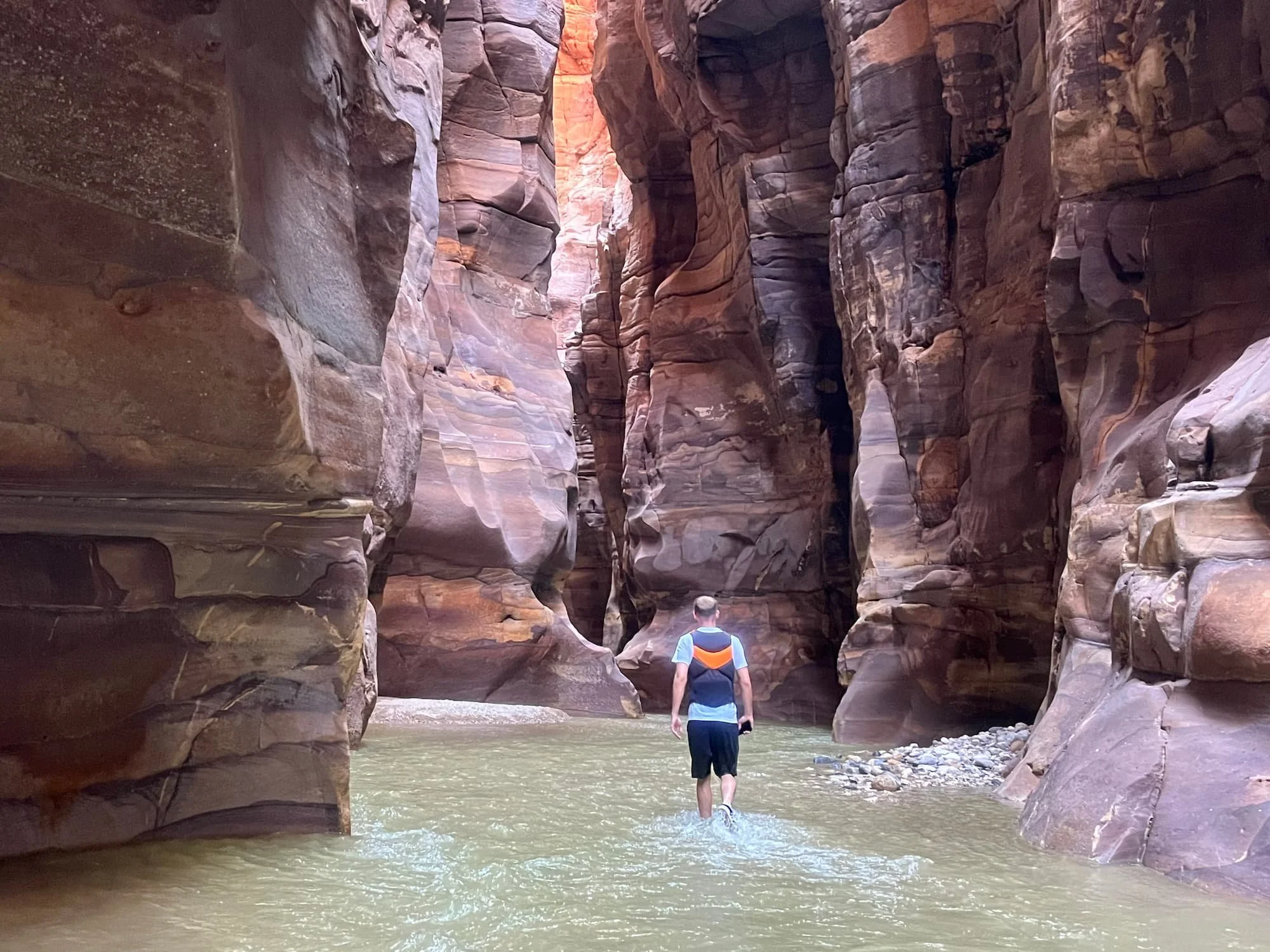
Image provided by Tom Henty’s Travel
Engel's Peak Meadows in Tajikistan
If you’re looking to hike in Central Asia, consider Engel’s Peak Meadows hike in Tajikistan. It is one of the most beautiful and accessible hikes along the Pamir Highway in Tajikistan. The hike is so named because it ends in a large meadow with uninterrupted views of Engel’s Peak. The Engel’s Peak summit is 6,510 metres and will require a few days, a guide and some technical equipment. However, the hike to Engel’s Peak Meadows is a moderate day or overnight hike that most people will be able to complete.
The Engel’s Peak Meadows hike can start in Dirch, Zong, or Langar, all small towns in the Wakhan Valley in Tajikistan. The hike is a 20km out-and-back trail, depending on where you start. There is an option to bring your camping gear and set up camp in Engel’s Peak Meadows for the night, or the whole return hike can be completed in around 8 hours. There is an 800-metre elevation gain from 3,200 to 4,000 metres. It is best attempted after having a few days to acclimatise first.
The hike weaves up and around the mountains with incredible views of the nearby ranges. The Panj River below forms the natural border between Tajikistan and Afghanistan, and you can see Afghan farmers and shepherds going about their day. Beyond that, you can see all the way to the awe-inspiring Hindu Kush mountain range in Pakistan. Hiking to Engel’s Peak Meadows is a great way to experience this remote and unique part of the world. You will likely not pass any other hikers on the trail, except maybe a local shepherd herding their goats.
Shared by Liza from Atlas Rambler Travel Guides

Image provided by Atlas Rambler Travel Guides
Umm Al-Biyara at Petra in Jordan
When looking for the best hikes in Asia, it’s hard to beat going for a hike around one of the Modern Wonders of the World.
Petra is pretty much on everyone’s bucket list, with good reason. But did you know that besides the most famous and picturesque carved buildings, you can also do incredible hikes?
There are eight different trails when you visit Petra, some of them cover the main sights where all tourists go but a couple of them are super quiet and offer you a wonderful opportunity to admire the beauty of the rugged desert landscape.
When you enter the enclosed UNESCO World Heritage Site of Petra, you will find a map of the area, with the eight trails marked. If you’re looking for a hike in Petra, I strongly recommend you do number five: The Umm Al-Biyara Trail.
It’s only four kilometres long, but remember that you will walk a lot during your time in Petra. The map where all the trails are shown defines trail number five as a hard intensity trail with a duration of 3-4 hours.
The Umm Al-Biyara Trail is a bit remote for Petra standards; I only saw four other hikers when I did it. It’s steep at times, but that means you will be approaching some breathtakingly beautiful views when you make it to the top of the mountain, where you will find a sense of peace and tranquillity.
This was my favourite hiking trail in Petra!
Shared by Juan from Planet of Adventures
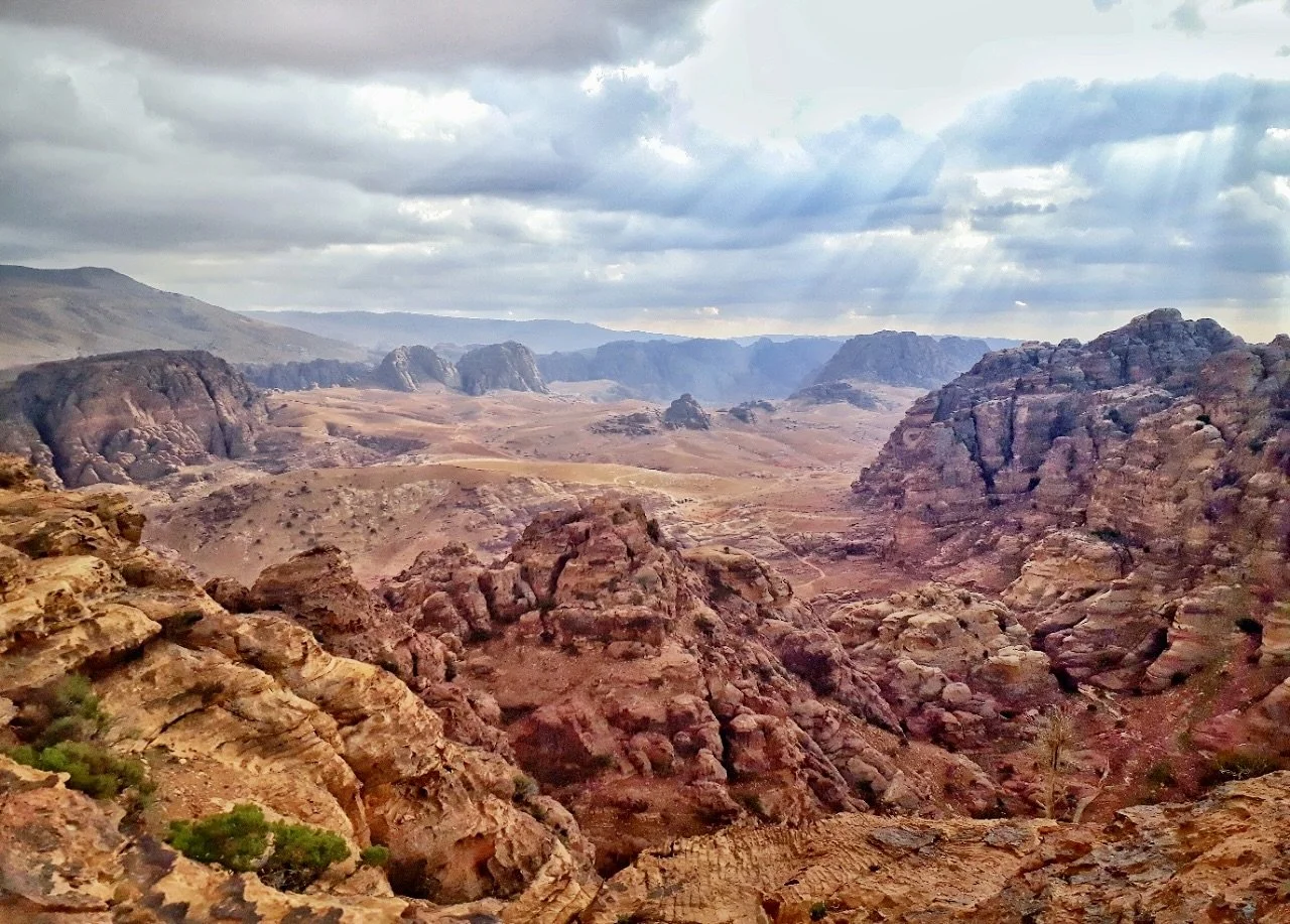
Image supplied by Planet of Adventures
Emerald Lagoon in Thailand
If you're hunting for one of the finest hiking experiences in Asia, the Emerald Lagoon at Railay in Thailand should be on your list. This hike is not just about the destination; it’s an adventure that takes you through muddy trails and challenging landscapes in Krabi. The vertical climbs can be quite demanding, so hiking with a friend can make the journey safer and more enjoyable.
As you prepare for this hike, it's crucial to consider the physical challenges ahead. Pack plenty of water, as staying hydrated is key to enjoying your trek. A good rule of thumb is to bring at least two bottles per person, as the humidity can be quite intense, even on cloudy days.
Patience is a virtue when it comes to reaching the Emerald Lagoon. The descent can be time-consuming, and with only one path available, you may find yourself waiting for others to pass. However, the reward is well worth the effort. Once you finally arrive at the lagoon, you’ll be greeted by a tranquil oasis, perfect for a refreshing swim away from the hustle and bustle of tourist hotspots. This hidden gem offers a serene escape, making the hike an unforgettable experience.
Shared by Paulina from the UK Every Day

Image supplied by UK Every Day
Plank Walk at Mount Huashan in China
One of the more fear-inducing hikes you can do in Asia is the Plank Walk at Mount Huashan in China. It’s exactly how it sounds: walking on planks on the side of a mountain.
Mount Huashan, or Mount Hua, is located just outside Xi’an and is one of the Five Sacred Mountains of China. The mountain consists of two cable cars and five peaks with 90º angled stairs, steep drop-offs and, of course, the infamous plank walk.
The plank walk is a small section of the mountain on the south peak and is a completely optional hike for adrenaline junkies. You’ll need a harness before descending iron pegs welded into the mountain. Below the steps is the valley floor hundreds of feet below. There are also cutouts in the rock wall for foot holes as you make your way to the planks.
The planks on the side of the mountain are only about a foot wide and look like they’ve seen better days. A small chain link connects to your carabiners as you make your way along the trail.
When you get to what looks like the end, it’s actually not. You have to turn around and go back to where you came from! It’s a fairly short hike. How long it takes you depends on your nerves. It’s definitely a bucket list hike if you’re up for it!
Submission by Ashley Jansen of Jetset Jansen
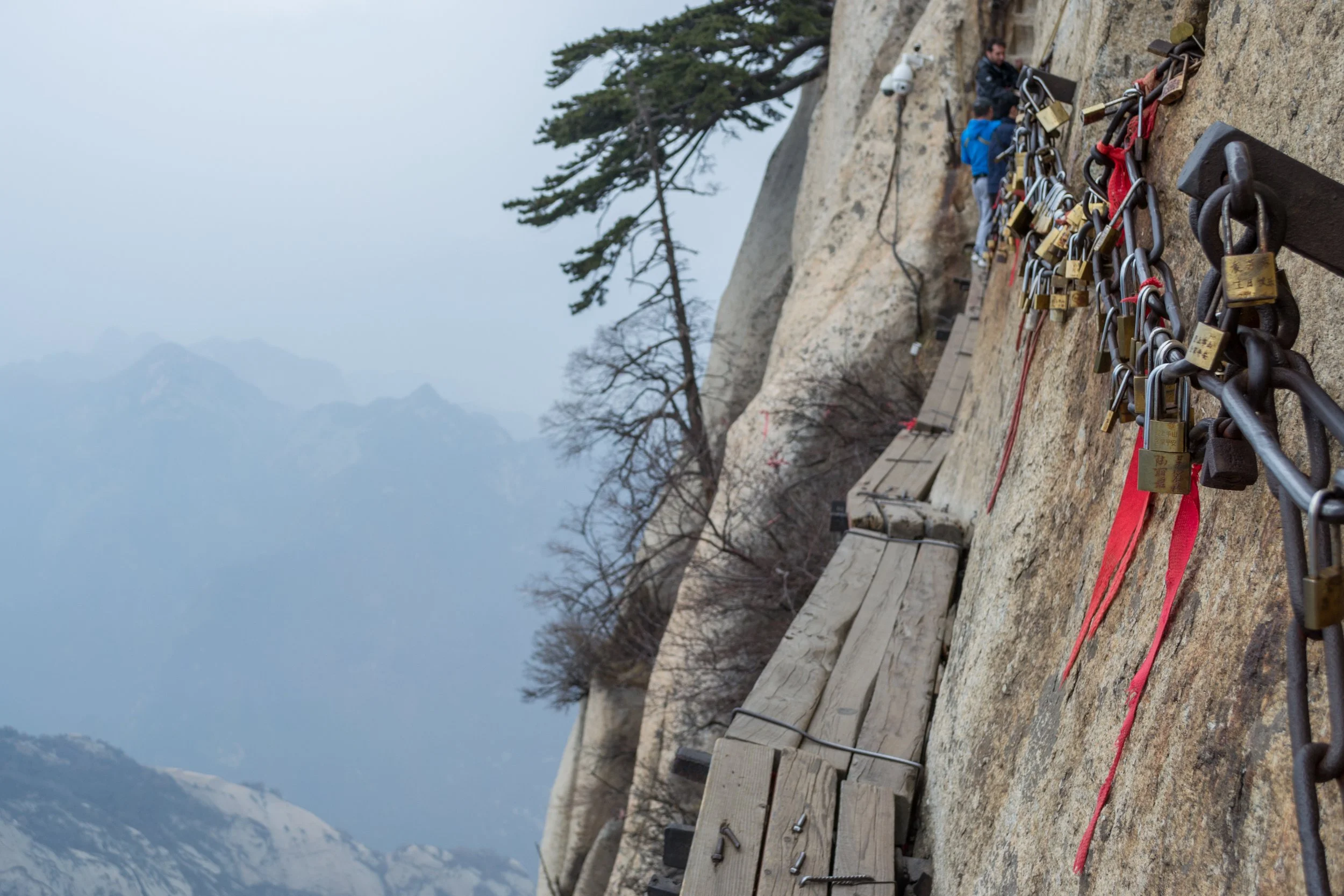
Image supplied by Jetset Jansen
Ella Rock in Sri Lanka
Hiking up to Ella Rock is often regarded as one of the best hikes in Sri Lanka, and it’s a great way to experience the stunning mountains of Sri Lanka’s Hill Country. Part of the Pekoe Trail, the hike is easy to moderate, offering just the right amount of challenge without being too intense. I did the hike in the afternoon, and there were very few hikers on the trail then, making it feel even more special.
I rented a tuk-tuk (I highly recommend doing this!), so getting to the starting point was super convenient. If you’re not driving yourself, the easiest way to trailhead is by taking a quick train ride from Ella Station to Kitha Ella Trail Station. From there, walk along the trail to reach the trailhead within 5 minutes.
The trail takes you through tea fields and forests before leading to the summit, where two main viewpoints await. My favourite spot was the second viewpoint, beside a small Buddhist monument. It was peaceful, and the breathtaking views made the climb completely worth it. If you plan to hang out at the top for a while, pack a pullover—it can get surprisingly chilly up there.
For an added treat, walk about 20 minutes further along the train trail after you finish the hike and visit Mama’s Restaurant. This cosy spot is run by a lovely elderly lady who made us the best curry and cinnamon tea I’ve ever had (probably because most ingredients come straight from her garden). The food is delicious, affordable, and a great way to support a local business.
If you’re in Ella and looking for an adventure with amazing views, this hike is a must-do!
Shared by Sophia Molnar from The Always Wanderer

Image supplied by The Always Wanderer
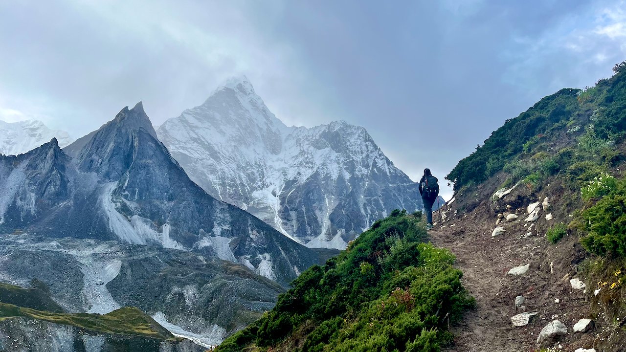
Everest Base Camp Trek in Nepal
The Everest Base Camp (EBC) trek is one of the most beautiful hikes in Asia, offering the chance to witness the world's tallest mountain, Mount Everest, standing at a staggering 8,849 meters.
As twin travellers and hiking enthusiasts, Atchaya and Agalya, we did the EBC and Three Passes trek, which remains one of the most rewarding adventures of our lives.
Starting from Lukla (2,520 m or 8,268 ft) and climbing to the Everest Base Camp (5,286 m or 17,343 ft), the trek covers an altitude gain of 2,766 m (9,075 ft). Of many routes leading to the Everest Base Camp, the Three Passes route is the most scenic and challenging option, taking about 17 days.
With daily hikes of five to eight hours, the trek demands physical and mental endurance, making it ideal for experienced hikers seeking an unforgettable challenge.
The trail winds through snow-capped peaks of the Himalayas, remote villages, and rivers, offering breathtaking views. The Khumbu region is home to the Sherpa community, known for its warm hospitality and rich mountain culture. Staying in tea houses along the route provides a cosy, authentic experience and the opportunity to connect with locals.
One of the trek’s advantages is its flexibility—you can hike independently or with a guide.
If you’re up for the challenge, this journey promises adventure and memories to last a lifetime.
Shared by Atchaya and Agalya from Twins on Toes
Images supplied by Atchaya and Agalya
Dzukou Valley in Nagaland, India
Dzukou Valley is one of my favourite trekking spots in Northeast India. It is located in the Kohima district at the border of Nagaland and Manipur. Dzukou Valley is at an altitude of 2,452 metres above sea level.
The valley's name is based on a local Angami Naga dialect, which means ‘dull and soulless’ as nothing could be cultivated there. The landscape of high hills, uniform smaller hills, colourful flowers, and the peaceful river down the valley attracts hikers to this spot.
I have trekked to Dzukou Valley six times and loved each of the experiences. The valley is greener during the rainy months. During this time, I saw the Dzukou lily flower found only in the valley, blooming to its fullest along with other white, yellow and brown flowers.
During winter, the river freezes, and the valley below becomes slightly white with frost in the morning. It also snows at Dzukou Valley too. Alas! I have missed the opportunities of snowfall every time.
The best time to visit Dzukou Valley, therefore, would be during monsoon months for flowers and the winters for the frost and snow experience.
The trek takes about three to five hours, depending on the individual's pace. It can be done by a beginner, too.
The Dzukou Valley trek can be done via two trails - Jakhama and Viswema. The latter is relatively easier than the Jakhama trail. Both trailheads are about half an hour's journey from Kohima - the capital of Nagaland.
The nearest railway station is in Dimapur, about 70 km away. Dimapur also has a regional airport.
For accommodation, every hiker must stay at the Dzukou Valley Campsite run by the caretakers assigned by the Southern Angami Youth Organisation (SAYO).
Shared by Joydeep Phukan from The Gypsy Chiring
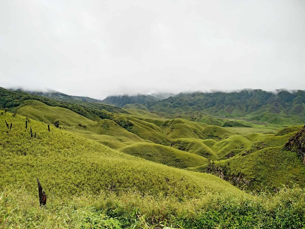
Image supplied by The Gypsy Chiring
Mount Bromo in Java, Indonesia
If you're looking for a unique experience, you shouldn't miss Mount Bromo in Java, a highlight on any Indonesian itinerary. Seeing the volcano from the top and walking along the crater is special. That's why Mount Bromo is one of Indonesia's most popular volcano hikes.
The best thing about this hike is that one can drive quite far up the volcano, so it’s a doable tour for anyone – regardless of age and fitness level. You have to walk up the last steep bit, but the rewarding view from the top is simply priceless.
You can drive up by yourself (I would not recommend a scooter, though, as it can get very sandy and slippery), or you can book a tour with a local guide. Many guides take you up for sunrise, watching the volcano come to life from a nearby mountain. This means you have to get up very early (basically in the middle of the night), but you will be rewarded. You can also stop at a small local coffee shop for hot chocolate and a small breakfast.
After watching the sun rise over the volcano, you can drive across the national park, closer to Mount Bromo and walk all the way up to the crater, which is very impressive. The way up is steep, and parts are pretty sandy, so bring proper shoes.
Although I have done several volcano hikes in different parts of the world – and each is extraordinary for different reasons – standing at the rim of an active volcano from which smoke is emerging is an unreal experience.
So when you travel to Indonesia, don’t miss this special experience.
Shared by Jill from Jill on Journey

Image supplied by Jill on a Journey